
08 August 2012
HURRICANE ERNESTO CHASE: Quick Debrief!
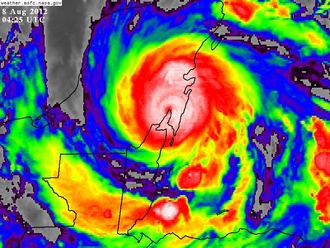
I honestly wasn't planning on chasing Ernesto. Scott Brownfield and I decided I wouldn't. But very early yesterday morning, the storm started to give me vibes—just the look of it on infrared satellite imagery. And I knew I had to chase it.
I packed a bag and rushed to the airport—and then from Cancun rushed down the Yucatan Peninsula to meet Ernesto's tiny but powerful core as it roared ashore in the swampy darkness.
Like all chases, it will get a full write-up. But here's the quick summary:
- Chase Location. I rode out the storm in a roadside restaurant in Buena Vista, near 18.882N 88.244W, which is WNW of Costa Maya/Mahahual.
- Pressure & Proximity. The lowest pressure of 975.0 mb (recorded with a Kestrel 4500) occurred at 12:34 am CDT, with the winds seeming to peak and coming roughly from the W at that time. I never had a lull. Based on all this, I think I was a mile or two S of the center. **(See later note, below.) Today I noticed that in Limones, approx. 10 mi to the N, the trees were bent the opposite direction—so my theory is that the very small eye passed between the two towns.
- Dimensions. The cyclone was very small: the winds did not become destructive until about 30 minutes before the center's closest approach. It was about 12 midnight when it suddenly came roaring in, and the worst of it was over within about one hour. The sharp V-shape of the air-pressure trace (recorded with my Kestrel 4500) is the classic barogram signature for a small, intensifying, deep-tropical hurricane. The gradient was extremely sharp: at one point, the pressure was dropping 1 mb every 2 minutes.

All of the above analysis is preliminary. I need to look at it all more closely—particularly my location with respect to the center.
Re: video... I shot some, but I don't know how good it is. It was very dark and the conditions were not great. I'll be reviewing the footage over the weekend, and I'm hoping to pull something together that captures the experience.
Big, enormous thanks to the iCyclone team—especially Scott, who deftly maneuvered me into position during those final, hectic hours. He's a total pro. This was a tough chase and it wouldn't have been as successful without Scott, as well as additional assistance from Adam and Steve.
—Josh Morgerman
**Note (09 Aug 2012): Based on close radar analysis done after this entry was written, it actually seems the center may have passed just to the S—not the N. Wind direction was not clear at the time due to darkness and my staying in shelter during the peak of the storm. I need to review the video footage for clues. A verdict will be made for the final report. Either way, it was extremely close.