
30 October 2012
Hurricane SANDY: How does it stack up historically?
Note: This article was later updated to reflected data from the official National Hurricane Center report.
A mostly low-drama Atlantic hurricane season ended with a smashing finale last night when Hurricane Sandy came roaring ashore in the Northeast USA—hitting the New York Metro region particularly hard.
OK, maybe it wasn't a classic tropical cyclone with a real core when its center crossed the New Jersey coast. Maybe it wasn't technically even a hurricane by that point. Maybe it really was just a nor'easter. Indeed, the satellite imagery is almost laughable: this does not look like a hurricane. (See image, below.)
No matter: it was a monster cyclone that will be remembered—in a way that Hurricane Irene of last year won't.
Right now, Sandy feels "huge".
So... How bad was it? How does it compare historically?
It's hard to know just yet—the impact is still being assessed. And I think it's important not to overreact to it—not to rate it higher because it just happened and it feels fresh. This having been said, some of the key metrics suggest Sandy will rank up there with some of the bigger Northeast-USA hurricane events of the last century:
- Central Pressure. Sandy's estimated landfall pressure of 945 mb in New Jersey was very low—but not quite as low as the landfall pressure of the Long Island Express Hurrricane of 1938. In the 1938 storm, Bellport, NY, reported 946 mb—however, reanalysis suggests the actual central pressure was 941 mb. Given this, 1938 is still king by a solid margin.
- Winds—Estimated. Sandy's max sustained winds at landfall were estimated at 70 kt. Several other 'canes have had higher estimated winds at landfall in the Northeast USA: 1938 (105 kt), 1944 (90 kt), Carol 1954 (100 kt), Edna 1954 (95 kt), Donna 1960 (85 kt), Gloria 1985 (75 kt), and Bob 1991 (90 kt). So Sandy's estimated max winds were nothing that unusual. However...
- Winds—Observed. Sandy's angle of approach and landfall point exposed Metro NYC to the strongest winds in the potent NE quadrant—very unusual—and that made a difference. All four major NY-Metro airports had Cat-1 hurricane gusts: EWR: 68 kt, JFK: 74 kt, LGA: 64 kt, ISP: 78 kt. This might not sound like a big deal to people along the Gulf Coast or in the Caribbean, but up north of the Mason-Dixon Line, that's huge. I don't believe that's happened in any other past cyclone.
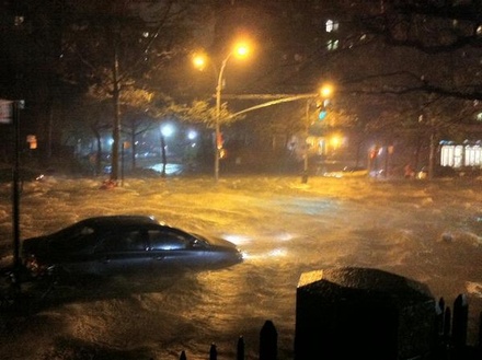
- Storm Surge. In NYC, Sandy's surge of 13.88 ft at Battery Park beat the old records of 10.02 ft set by Hurricane Donna of 1960 and the even higher 11.2 ft estimated to have occurred in the hurricane of 1821. Large portions of Manhattan are under water—due largely to the "perfect approach angle" that exposed NYC and Long Island to the strongest winds, from a direction that perfectly funneled water up into New York Harbor. A majority of Atlantic City, NJ, was underwater at one point yesterday—and there was widespread, very severe surge flooding across other areas of New Jersey, New York, Connecticut, and Rhode Island. Reports indicate record, once-in-a-lifetime inundation on both shores of the Long Island Sound. Kings Point, NY, measured a tremendous 12.65 ft above normal.
- Size. This was a real differentiator for Sandy. We measure a cyclone's size by the radius of gales (34-kt winds) from the center. By this metric, Sandy was one of the largest cyclones—if not the largest cyclone—of tropical origin ever to hit the USA, with a gale radius of up to ~480 mi (420 n mi) and a diameter of almost 1,000 miles! That exposed an enormous stretch of American coastline—and many millions of residents—to dangerous winds. More importantly, it was the enormous coverage of these winds that helped propel record storm surges along such a large stretch of coast—all the way up to eastern New England.
- Fatalities & Damage. Sandy is blamed for 72 deaths and $50 billion in damage in the USA. So, fatalities are significant but lower than past, midcentury hurricane disasters in the Northeast USA—however, the dollar-damage figure is exceedingly high.

And let's not forget..

Sandy, at landfall in Cuba. Note the distinct eye straddling the coast.