
07 October 2013 - 7:45 am JST
Chasing DANAS: A provocative scenario.
It's morning here in Naha, Okinawa, and we have a rather provocative scenario developing—a powerful typhoon accelerating in our direction.
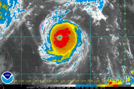
Typhoon DANAS looks to be strengthening and has a gorgeous, tight little structure, with a distinct eye and eyewall. In fact, the JTWC now puts the intensity at a strong 105 knots (120 mph), and they forecast it to get up to 115 knots (130 mph) later today, as the center crosses the Ryukyu Islands. That's a Cat 4 on the scale we use in the Atlantic.
The 12Z Euro, 12Z GFS, and 18Z GFS computer models all bring the center of the typhoon over or near the N tip of Okinawa Island between 3 and 6 pm this afternoon. Extrapolating the motion seen on radar and satellite imagery also suggests collision with the N tip of Okinawa Island.
So, many of the indicators are pointing to a rather provocative scenario for chasers: the landfall of an intense cyclone during daylight hours.
Many things in this scenario can go wrong. It's a tease—plain and simple—and we can't get too worked up over it.
We need to just stay cool and head N—to the N tip if Okinawa Island.
—Josh Morgerman