
07 July 2014 - 10 am JST
Chasing NEOGURI: Battle of the dots.
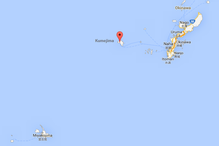
Quick... When you look at this map, what to you see?
Yep, lots of water. And a couple of dots—very far apart. And a lot of We have to pick one of those dots. Welcome to the unique pleasure of Western Pacific island chasing.
Basically, it's come down to Miyako-jima versus Kumejima. Super Typhoon NEOGURI seems to be shooting for the channel separating the two islands, so it's a matter of which is closer.
In summary: Kumejima seemed like a sure bet yesterday. The models and official agency forecasts all brought NEOGURI close to or overt the island. But the cyclone was trending left of the forecast tracks, and both the GFS and Euro nudged W—significantly so. iCyclone's lead Meteorologist, Adam Moyer, and I had a long chat overnight and agreed that Miyako-jima was back in play. But this morning, the cyclone has definitely made a hard right turn—a trend that seems to be more than just a wobble.
We're getting close to the final 24 hours—and it's around now that I start looking more at real-time indicators than models. And this means I'm obsessively refreshing the satellite loops, like a dog on his hind legs waiting for the new frame to load every 30 minutes.
James, Mark, and I discussed it over breakfast. In a nutshell, each option has its pluses:
Miyako-jima
- W trend in the models.
- Right (poleward) model bias normally seen in this basin—which suggests the actual track will be left of what's modeled.
- Further-S location means more of the storm will happen by daylight.
Kumejima
- This morning's right turn—very evident in the satellite loop.
- It will probably be on the cyclone's stronger (right) side.
—Josh Morgerman